
June 1st: A forecast for substantial instability but very little shear seemed like a recipe for storms to quickly grow and rain themselves out, and that’s exactly what transpired on this first day of meteorological summer. I was already in Gretna for other reasons so I rolled north on Rte 29 almost to Lynchburg before reversing course to check out activity coming out of North Carolina. Before I got very far I was distracted by a storm along the Blue Ridge that went severe warned so I punched west into Bedford county to check it out:
Other than a small lowering under the rain-free base and a shelf cloud out ahead of the rain shaft I saw nothing else of note from this cell. Thus I pulled off this storm as it moved northeastward along the mountains and instead continued southward to the Blairs vicinity along Rte 29. After waffling a while on which direction to go I wound my way north and west along rural roads, ending up near Penhook where I live-streamed for the five o’clock TV news without seeing anything noteworthy. On my way back home I was blocked for a bit by a squall line with embedded hail cores but I managed to miss them. It was pretty much a “whack-a-mole” kind of chase.
June 2: An almost identical setup to the previous day’s low end stuff almost kept me from heading back out. However the presence of a weak cold front and its shear zone interested me enough to roll down the driveway to check things out. Starting out near Bedford to avoid some early cells further south I trickled southward along Rte 122 in sort of rolling reconnaissance, looking for an interesting storm. Near Union Hall I stopped for quite a while to watch the slow-moving convection and live streamed more average stuff during the five pm TV broadcast.
When this activity weakened I headed back west into the Roanoke valley along Rte 220 but immediately diverted to a hilltop location at the south end of the valley. A convective line was pushing across the valley and my first glimpse seemed to show a wall cloud at the southern end. However this was likely just a perspective issue as an impressive shelf cloud showed up ahead of the rain as I sat and watched:
The final leg home meant driving through heavy rain and spattering of hail behind this shelf cloud and amid a Flash Flood Warning issued by NWS Blacksburg.
June 13th: The normally active first two weeks of June weren’t very busy in 2015. Thus by the time the second Saturday of the month arrived I was itching to go see something convective. Under a northwest flow regime I waited at home watching radar until after 4 pm when a line of storms crossed I-81 south of Lexington and chugged in the general direction of Lynchburg. Stopping in Bedford for gasoline I wound my way southward along Rte 122, bobbing and weaving to avoid multiple rain shafts. I did live stream for a bit from a hilltop location in Moneta but other than watching two storms converge little else of interest occurred. I called it a chase without continuing into the very busy Smith Mountain Lake location on a weekend.
June 14th: Given other obligations I had to allow a line of strong (and one severe) storms to pass by without giving chase. When more cells crossed West Virginia later in the day I “intercepted” them at a local park. As this suspicious looking base crossed the ridge lines to my west it corresponded to a broad area of rotation on radar: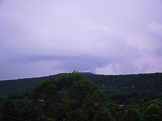
Seeing nothing else worthwhile I called it “chase” and drove the 3 minutes back home before dark.
June 17th: A decent setup looked even better when the SPC issued a mesoscale discussion that neatly overlaid my standard chase area. Even tho’ a nice storm (that eventually went severe) was cruising across Bedford county I dove south toward Rocky Mount and then headed east on Rte 40. While rolling along I saw a substantial wall cloud under a cell near Ferrum. At Glade Hill I motored south on a rural road to find a spot from which to watch this storm, which had a strong couplet via radar velocity:
I live streamed this storm during the 5 pm TV news before repositioning south and east to stay ahead of it.
Crossing a ridgeline just east of the hamlet of Sago I stopped to take advantage of the view of “my” storm as it cycled thru another wall cloud phase:
Also from this vantage point I could see the base of a severe-warned storm near Smith Mountain Lake. That cell also had a wall cloud underneath it.
Continuing south and east I found a spot in rural Pittsylvania county to stop and live stream the oncoming activity during the six o’clock news. Two storms approached my location with the southern one beginning to bow out as it neared:
This southern cell showed both greenage and some visible rotation as it passed by perhaps a mile south of me.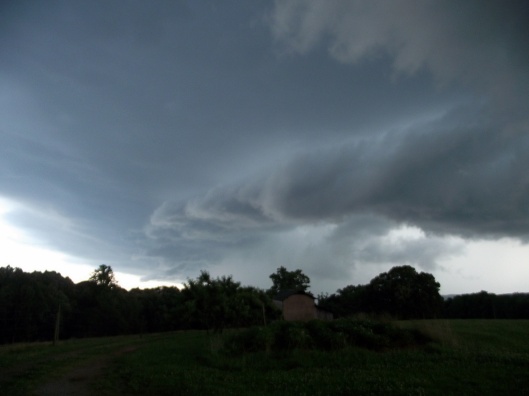
Fortunately I was in a seam of a building squall line so I let it pass my location with plenty of rain and lightning before pushing back westward toward home. I did stop and watch another cell south of Glade Hill that had a bit of a lowering for a while before the entire thing dissipated near sunset.
June 18th: My original southern target of Franklin and Henry counties was thwarted by a cirrus shield that inhibited convection. Thus after wandering around both counties for a while – partly to cool off via the a/c – I gave up on some waning convection and vaulted north to Rte 29 in an attempt to intercept a large complex near Lynchburg. Diverting east at Gretna I drove on back roads for a bit before deciding to push west toward Hurt to check out a storm coming from the northwest.
I live-streamed for the six o’clock news broadcast before diving south to stay ahead of this cell. After a feverish search for another open vantage point I stopped and took in this rapidly approaching shelf cloud:
Given the VIL signature on radar I realized this wasn’t a storm I wanted to core punch so I maneuvered on back roads south toward Gretna where I barely missed being steamrolled by the heavy rain and hail. Once things calmed a bit I headed for home.
